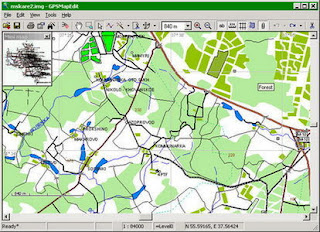
In addition, the software may be used for converting GPS-tracks, waypoints and routes among various formats. GPSMapEdit does not have installer now. The program installation does not require special efforts because the software is ready to run. Just download the latest version and unzip it into any suitable folder.
Features:
- Visualization of satellite images from Google Maps.
- Loading of huge raster maps (format OziExplorer MAP) - over 20-30 megapixels.
- Loading ECW and JPEG 2000 raster maps.
- Import from MapInfo MIF/MID.
- Export to MapInfo MIF/MID.
- Import POI from external table file with address data, the formats are: CSV, MS Excel XLS, MS Access MDB, dBase DBF, Paradox DB, Visual FoxPro.
- Splitting map to smaller files (the menu 'Tools | Split map to files...').
- Saving to CRD format (ALAN Map 500 and Holux).
GPSMapEdit 1.1 (update 75.1)
The change log:
New feature: Export to format Navikey 7 Ways .7W using the external convertor 7WaysConvC.exe (please see menu item 'File | Export | Navikey 7 Ways map (*.7w) / 7WaysConvC.exe').
New feature: Export to format CityGuide .DCM using the external convertor GeoConstructor.exe (please see menu item 'File | Export | CityGuide map (*.dcm) / GeoConstructor').
Enhancement: The type set "Navitel and Garmin" has been renamed to "Universal (Navitel, Garmin etc)". Now this type set is fully available in demo mode.
New feature: For the type set "Universal", new "3D" tab is available in the Properties window for polygons. It allows to define the number of floors of a building. This new feature corresponds to the non-standard attribute "Floors=", which one is supported by some of the format convertors (except cgpsmapper.exe).
In addition, the number of floors may be modified using corresponding item of the context menu.
Enhancement: The context menu item 'Show in 3D' is enabled for the type set "Universal" for polygons having floors.
The window "3D View" takes the floors into account on buildind 3D-scene.
Enhancement: In the "Map Properties" window, changing of the type set and pressing "Apply" button causes change of available tabs, if necessary.
Enhancement: In the "Map Properties" window, new tab for type set "Lowrance" and for "Navitel" is provided.
Enhancement: For the type set "Lowrance", the new non-standard attribute "LcmDivDepths=Y" is supported in the MP file header.
It may be turned on/off using the new tab "lcmBuilder" of the "Map Properties" window.
If the attribute is presented, all depth and elevation values are divided by 3.28084 (feet per meter) before exporting to Lowrance .LCM.
Enhancement: Export to Lowrance .LCM now supports the labels of water polygons 0x10, 0x12, 0x15 (thanks to: Roger Yost).
Fix: For the type set "Lowrance", the correct Lowrance grid is supported to round a coordinates. The step of the grid depends on latitude: it is equal to 1 meter at the equator, and diminishes onward to the poles, while the step along latitude and one along longitude are equal each other everywhere.
Fix: For the type set "Lowrance" and "ALAN/Holux", the drop-down list of special characters in "Object Properties" is disabled for the "Label" attribute.
Enhancement: For the type set "Lowrance" and "ALAN/Holux", merging of zoom levels now ignores "Bits" attribute while pasting objects and while map adding (thanks to: AlexSidorov).
Enhancement: On "File | Add...", zoom levels of added maps are compared with the target ones. Non-coincidence is reported to the "Message Log" (thanks to: AlexSidorov).
Enhancement: The precision of the distance measurement tool is increased for short distances.
Fix: Loss of precision while editing position as text (thanks to: Albert Semenov).
Fix: In "Verify Map...", false detection of polygon intersection in some cases is fixed (thanks to: Albert Semenov).
Fix: In "Split Map to Files...", splitting a routing node (thanks to: Andrzej Popowski).
Fix: Crash while editing huge number of points as text (thanks to: ???????? ??????).
Fix: Opening multiple shortcuts in 'File | Add...' (thanks to: Gary Turner).
Enhancement: Shortcuts may be dropped from Explorer to GPSMapEdit window.
Enhancement: Export to formats of maps, whose support is discontinued by the developers of corresponding navigation systems (Holux/ALAN .CRD and .ARD, RUSSA .RUS, Navitel .NTM and .NM2), has been moved to the new sub-menu 'File | Export | Obsolete Formats'.
Enhancement: Export to formats of tracks, waypoints and routes, whose support is discontinued by the developers of corresponding navigation systems, has been moved to the new sub-menu 'File | Export | Attached Waypoints/Track Logs/Routes to | Obsolete Formats'.
Fix: Loading of some waypoints from MapSource .GDB files (thanks to: Carlos E. Solorzano Landa).
Fix: Crash while saving very huge section "[DICTIONARY]" to MP file (thanks to: Wagner Kobayashi).
Enhancement: The attributes of MP header "POIZipFirst=" and "POINumberFirst=" are now saved regardless their value, provided that the attribute "POIIndex=Y" is on (thanks to: Andrzej Popowski).
Fix: The system setting "Don't save encrypted pages to disk" now does not cause the message "(Failed)" appearance in "Google Maps".
Enhancement: In the context menu 'Google Maps', the item 'Refresh All Visible Tiles' is added (thanks to: Gary Turner).
Enhancement: GUI localization for German is made more comprehensive.
Enhancement: GUI localization for Armenian is added (thanks to: Hrant Ohanyan). NOTE: if your Windows is not Armenian, please install the font "Tahoma Armenian" into the system.
Home Page:
http://adf.ly/CFWyX


0 comments:
Post a Comment